

- cross-posted to:
- shitposting@lemmy.ml
- cross-posted to:
- shitposting@lemmy.ml
You must log in or register to comment.
Also use a ruler to draw the lines. Straight through a village if you feel like it. Don’t even pretend to make an effort.
Interesting that the basis of the activity itself can’t help drawing borders around the middle east though, not just the natural ones in the Arabian peninsula, but Egypt and the eastern countries too. That itself is a form of bias.
Yeah that seems kinda on-theme
Turkey just eliminated outright.
The map should include major sources of valuable fresh water, for even more chaotic fun. For example, I’d draw two long, thin countries on each bank of the Nile.
Oops! All Rojava!
Straight lines and squares it is!
Why bother with pesky things like terrain and linguistic/cultural differences when everything could be perfectly square.
Egypt could have been even more square! Gimme that Halaib triangle to play with!
I propose enclaves and exclaves everywhere. Pros: forces everyone to cooperate, makes saturation attacks pointless, pleases the spirit of Jacques Fresco. Cons: none I think
Country “peninsulas” are cool too. You know those zen labyrinths?
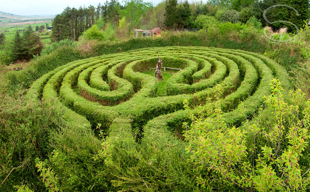
Imagine an entire village inside one. Everyone gets extra calm and introspective on their way to school/work/water! Or shot if they dare to take a shortcut.
It’s already perfect in the picture.
All Israel , time for some peace and quiet in the region
You know what I’m noticing? Too many vertical borders in the Middle East. I’m just gonna do horizontal borders, top to bottom, devided up so that each country gets an equal area of land. As for which country gets which sliver, let’s just make it simple and do alphabetical order (in English, obviously).
…annnnd done. Looking back over it, I forgot that N comes before Q so Iran and Iraq are switched, but I already drew it up, so, whatever, I’ll just leave it that way and leave it up to them if they wanna switch or not.
The 4 state solution. Dont mind the discontinuities, SA deserves that sliver of Egypt and Oman is basically Iran anyway (pronounced Eye-ran ofc)
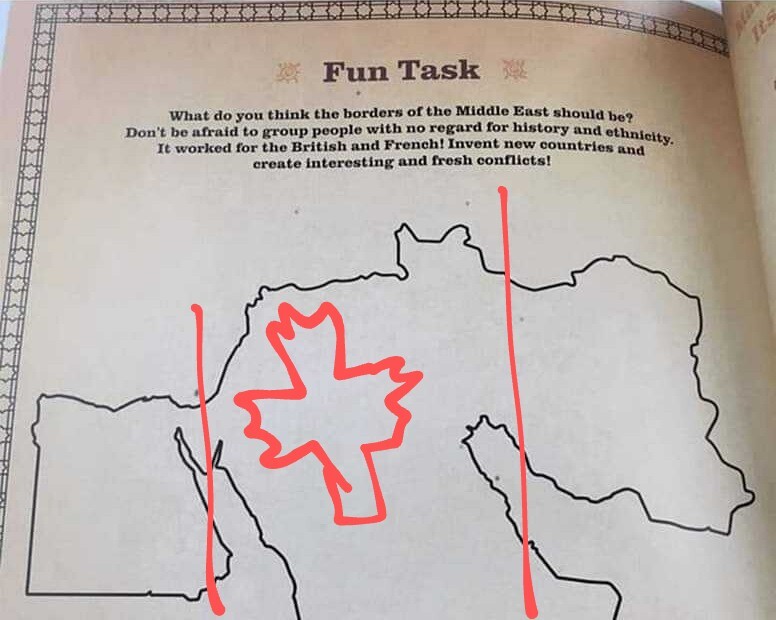
Just draw a line through the middle and call it East/West Fun-o-land.
Just draw a line through the middle and call it East/West Fun-o-land.
the west middle east.
The middle weast
Removed by mod
I propose dividing it up into sectioned off plots of an inwardly spiraling interior/exterior border line, having radially orthagonal borders with neighboring countries in the spiral. The middle country can be a few dozen square km circular blob. give the middle one nukes and offer them to join nato
Removed by mod
This should be one of the settings in NationStates you can pick for your nation. “How does your nation feel the Middle East should be divided?”
That was surprisingly fast and easy to fix!

all albania
I always thought the British got a slightly worse rap than they deserved there. When the Ottoman empire collapsed, things were chaotic to say the least. Rising nationalism in an area where ethnicities are all over the place. A pocket here, a few villages there. Political systems that had been in place for a thousand years disintegrating. Large groups of nomads who are notoriously difficult to fit into ordered nation states.
Huge demographic shifts underway. People tend to overlook just how much more crowded the world is now than it was in 1920. What worked in 1890 was a nonstarter in 1990.
I don’t think any line on that map would have substantially changed things one way or another.


